Citations
Curral De Arame Watershed Erosive Susceptibility Map, Dourados/Ms- Brazil
Carta de susceptibilidade erosiva da Bacia Hidrográfica do Córrego Curral de Arame, Dourados/MS
Open | Download
Issue
Section
Articles
How to Cite
Curral De Arame Watershed Erosive Susceptibility Map, Dourados/Ms- Brazil. (2020). Revista EIA, 17(34), 1-12. https://doi.org/10.24050/reia.v17i34.1409
Dimensions


license

This work is licensed under a Creative Commons Attribution-NonCommercial-NoDerivatives 4.0 International License.
Copyright statement
The authors exclusively assign to the Universidad EIA, with the power to assign to third parties, all the exploitation rights that derive from the works that are accepted for publication in the Revista EIA, as well as in any product derived from it and, in in particular, those of reproduction, distribution, public communication (including interactive making available) and transformation (including adaptation, modification and, where appropriate, translation), for all types of exploitation (by way of example and not limitation : in paper, electronic, online, computer or audiovisual format, as well as in any other format, even for promotional or advertising purposes and / or for the production of derivative products), for a worldwide territorial scope and for the entire duration of the rights provided for in the current published text of the Intellectual Property Law. This assignment will be made by the authors without the right to any type of remuneration or compensation.
Consequently, the author may not publish or disseminate the works that are selected for publication in the Revista EIA, neither totally nor partially, nor authorize their publication to third parties, without the prior express authorization, requested and granted in writing, from the Univeridad EIA.

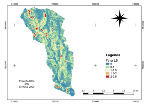
Water erosion is a natural process that is intensified by the lack of conservation practices, soil vegetation cover misuse and removal. It has as a consequence, soil impoverishment, sil- ting and water bodies eutrophication, among others. Importance fundamental to erosive pro- cesses become aware so that decision makers adopt mitigation and/or prevention measures for this phenomenon. The USLE enters as a tool to soil loss by laminar erosion estimate. The Geographic Information Systems (GIS) use has been shown efficient to erosive susceptibility characterize, due to the ease of data collection. Many of these are available for free, such as QGIS software and environment dates. This project aimed to map and qualitatively analyze the Curral de Arame Watershed erosive susceptibility, using free GIS and environmental dates. Annual soil loss estimating values under study ranged from 0 to 389 tons per hectare per year. The greatest influence factor observed was CP factor - Use and Management and Conservation Practices, due to the region moderate slope.
Article visits 440 | PDF visits 317
Downloads
Download data is not yet available.