Citations
Estimation of the change in water regulation capacity in response to changes in land cover
Estimación del cambio de la capacidad de regulación hídrica como respuesta a los cambios de coberturas de la tierra (Case study: Upper Chinchiná river basin, Caldas, Colombia)
Open | Download
Issue
Section
Articles
How to Cite
Estimation of the change in water regulation capacity in response to changes in land cover : (Case study: Upper Chinchiná river basin, Caldas, Colombia). (2020). Revista EIA, 18(35), 35004 pp. 1-12. https://doi.org/10.24050/reia.v18i35.1465
Dimensions


license

This work is licensed under a Creative Commons Attribution-NonCommercial-NoDerivatives 4.0 International License.
Copyright statement
The authors exclusively assign to the Universidad EIA, with the power to assign to third parties, all the exploitation rights that derive from the works that are accepted for publication in the Revista EIA, as well as in any product derived from it and, in in particular, those of reproduction, distribution, public communication (including interactive making available) and transformation (including adaptation, modification and, where appropriate, translation), for all types of exploitation (by way of example and not limitation : in paper, electronic, online, computer or audiovisual format, as well as in any other format, even for promotional or advertising purposes and / or for the production of derivative products), for a worldwide territorial scope and for the entire duration of the rights provided for in the current published text of the Intellectual Property Law. This assignment will be made by the authors without the right to any type of remuneration or compensation.
Consequently, the author may not publish or disseminate the works that are selected for publication in the Revista EIA, neither totally nor partially, nor authorize their publication to third parties, without the prior express authorization, requested and granted in writing, from the Univeridad EIA.

Show authors biography


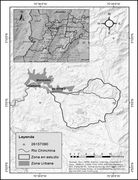
Human occupation and its productive activities give rise to changes in coverage, which affect ecosystem services and specifically water regulation services. The upper basin of the Chinchiná River is a basin that has presented changes in its vegetation covers and this change affected its water regulation system, this conclusion was reached by carrying out the multi-temporal analysis of the covers and the hydrological analysis through the construction of the flow duration curves for the years with geospatial information. Among the results, it was found that, due to its initial conditions in the characteristics of the soil and vegetation cover, the upper basin of the Chinchiná River does not have a good capacity to regulate surface runoff, a fact that is aggravated by the expansion dynamics of the herbaceous and pasture covers during the study years. The knowledge of the relationship between changes in coverage and the regulation of surface runoff, allows projecting the appropriate use of the land in order not to further affect the capacity to regulate surface runoff that serves as the foundation of biodiversity, supply of the city of Manizales.
Article visits 918 | PDF visits 661
Downloads
Download data is not yet available.
- Adrien Chevallier, Fernando González-Roca, Matías Portflitt-Toro, Jonathan A. Fortt, Nicolás Luna, Osvaldo Cerda, Daniela M. Carranza, Francisco A. Squeo, Carlos F. Gaymer, National trends in the biodiversity interest in digital media, Environmental Science & Policy, Volume 101, 2019, Pages 106-115, ISSN 1462-9011.
- Instituto Humboldt, (2017). Biodiversidad colombiana: números para tener en cuenta.
- The Nature Conservancy, (2019). Proteger la diversidad biológica de Colombia con políticas públicas.
- Marín Ramírez, R. (2003). III SEMINARÍO DE ACTUALIZACION EN INGENIERIA AMBIENTAL, “GESTION DEL RECURSO HIDRICO EN COLOMBIA”. Bogotá, Colombia.
- Aguas de Manizales S.A. E.S.P., (2019). Presentación Aguas de Manizales abril 2019, Manizales. Colombia.
- Periódico El Tiempo, (2017). Planta de agua de Niza, en Manizales, ya genera su propia electricidad. Colombia., https://www.eltiempo.com/colombia/otras-ciudades/aguas-de-manizales-ya-genera-energia-electrica-con-turbina-en-planta-de-niza-141040
- Lazo, P. X., Mosquera, G. M., McDonnell, J. J., & Crespo, P. (2019). The role of vegetation, soils, and precipitation on water storage and hydroogical service in Andean Páramo catchment. Jornal if Hydrology, 805 - 819.
- José Manuel Camacho-Sanabria, José Isabel Juan Pérez, Noel Bonfilio Pineda Jaimes, Edel Gilberto Cadena Vargas, Luis Carlos Bravo Peña y Marcela Sánchez López, Coverage/land use changes in a portion of the Mountainous Mexican Transition Zone, Madera y Bosques vol. 21, núm. 1: 93-112 Primavera 2015.
- Martínez, C. (2011). Estadística aplicada. Pearson Educación. Tomado de http://www.ebooks7-24.com.ezproxy.umng.edu.co/?il=8866
- Moreno-Sánchez, M., Hincapié, G., Ossa, C.A., y Toro-Toro, L.M. 2016. Caracterización geológico-estructural de algunas zonas de cizalla en el Complejo Quebrada grande en los alrededores de Manizales y Villamaría. Boletín de Geología, 38(4): 15-27.
- Corporación Autónoma Regional de Caldas, (2020). Catálogo de especies de flora y fauna: sub-region occidente prospero del departamento de Caldas. Colombia.
- M.C. Otalora, J.S. Hernández, (2018). Estimación de los índices hídricos (IUA, IRH, IVH) y formulación de medidas parala mitigación del desabastecimiento en la subcuenca arroyo grande corozal (2502- 01-07) de la cuenca río bajo san Jorge. Universidad Católica de Colombia, Facultad de ingeniería, Bogotá D.C., Colombia.
- Instituto de Hidrología, Meteorología y Estudios Ambientales IDEAM, (2018). Estudio Nacional de Agua 2018, Colombia.
- Javier Sánchez, (2013). Curva de caudales clasificados, Universidad de Salamanca, España., http://hidrologia.usal.es/Complementos/Curvas_de_Q_clasificados.pdf
- Juan Salazar, (2016). Una metodología para la estimación de curvas de duración de caudales (CDC) en cuencas no instrumentadas. caso de aplicación para Colombia en los departamentos de Santander y norte de Santander, Universidad Nacional de Colombia, Colombia.
- Martha García Herrán, (2013). Seminarío – taller Uso de las cuentas de capital natural en la política pública WAVES. Bogotá. Colombia., https://www.wavespartnership.org/sites/waves/files/documents/WAVES-Presentaci%C3%B3n-ENA2010_sep_26_2013.pdf
- Rafael Antonio Becerra Rodríguez, (2017). Balance hídrico de la cuenca abastecedora de la planta de tratamiento de agua potable “Luis Prieto Gómez” en la vereda gallinazo de Villamaría caldas, Universidad Nacional Abierta y a Distancia, Medellín. Colombia.