Citations
Spatial evaluation of potential áreas of specialty coffee distribution centers, case of the Department of Nariño - Colombia
Evaluación espacial de zonas potenciales de centros de distribución de cafés especiales, caso del Departamento de Nariño - Colombia
Open | Download
Section
Articles
How to Cite
Spatial evaluation of potential áreas of specialty coffee distribution centers, case of the Department of Nariño - Colombia. (2022). Revista EIA, 19(38), 3810 pp. 1-22. https://doi.org/10.24050/reia.v19i38.1542
Dimensions


license

This work is licensed under a Creative Commons Attribution-NonCommercial-NoDerivatives 4.0 International License.
Copyright statement
The authors exclusively assign to the Universidad EIA, with the power to assign to third parties, all the exploitation rights that derive from the works that are accepted for publication in the Revista EIA, as well as in any product derived from it and, in in particular, those of reproduction, distribution, public communication (including interactive making available) and transformation (including adaptation, modification and, where appropriate, translation), for all types of exploitation (by way of example and not limitation : in paper, electronic, online, computer or audiovisual format, as well as in any other format, even for promotional or advertising purposes and / or for the production of derivative products), for a worldwide territorial scope and for the entire duration of the rights provided for in the current published text of the Intellectual Property Law. This assignment will be made by the authors without the right to any type of remuneration or compensation.
Consequently, the author may not publish or disseminate the works that are selected for publication in the Revista EIA, neither totally nor partially, nor authorize their publication to third parties, without the prior express authorization, requested and granted in writing, from the Univeridad EIA.

Show authors biography


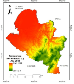
The specialty coffees of the Department of Nariño have been recognized worldwide for their excellent quality, but they have been affected by the inadequate handling of the product in its supply chain, specifically in the areas where it is stored, directly affecting its differential attributes, therefore which presents an approach to solve the problem of selection and location of possible potential areas, for the establishment of a distribution center. In the present study, a decision-making approach with multiple criteria (MCDA) was applied, specifically the analytical hierarchy process (AHP) and weighted linear combination (WLC), with the incorporation of geographic criteria and their implementation in GIS (Geographical Information Systems). 38 possible alternatives (Producing Municipalities) were evaluated, using criteria previously identified with the help of experts: Municipal production, road connectivity and average temperatures. As a result, a map was obtained at the departmental level of possible potential zones and unsuitable zones. In conclusion, we can affirm that as the number of criteria increases, it implies greater complexity for decision-making. The methods, criteria and data sets used, the results obtained and discussion, finally the most significant conclusions, are described in detail.
Article visits 1079 | PDF visits 692
Downloads
Download data is not yet available.
- Agricultura, M. de (2019) Estadistica Agropecuaria - Agronet. Available at: https://www.agronet.gov.co/Paginas/inicio.aspx (Accessed: 10 December 2019).
- Akinci, H., Özalp, A. Y. and Turgut, B. (2013) ‘Agricultural land use suitability analysis using GIS and AHP technique’, Computers and Electronics in Agriculture, 97, pp. 71–82. doi: 10.1016/j.compag.2013.07.006.
- Alonso, A., Hidalgo, A. and Izquierdo, M. (2006) ‘Proceso Gerarquico AHP’, El acceso a la información espacial y las nuevas tecnologías geográficas, pp. 579–596. Available at: http://tig.age-geografia.es//docs/XII_2/042 - Alvarez Alonso et al.pdf.
- Andes, U. de los (2015) Los Cafés Especiales, una alternativa para los caficultores colombianos. Available at: https://agronegocios.uniandes.edu.co/2015/09/23/los-cafes-especiales-una-alternativa-para-los-caficultores-colombianos/.
- Ciguenza, N. (2019) Huila es el departamento líder cafetero con 16% del área cultivada, La república. Available at: https://www.larepublica.co/especiales/ruta-del-cafe/huila-es-el-departamento-lider-cafetero-con-16-del-area-cultivada-2840686.
- Clavijo, S. (2020) Panorama cafetero 2019-2020, La república. Available at: https://www.larepublica.co/analisis/sergio-clavijo-500041/panorama-cafetero-2019-2020-2920631 (Accessed: 9 May 2020).
- Cómo funciona IDW—Ayuda | ArcGIS for Desktop (no date). Available at: https://desktop.arcgis.com/es/arcmap/10.3/tools/spatial-analyst-toolbox/how-idw-works.htm (Accessed: 25 August 2020).
- DANE (2016) 3er Censo Nacional Agropecuario: Resultados. Available at: https://www.dane.gov.co/files/images/foros/foro-de-entrega-de-resultados-y-cierre-3-censo-nacional-agropecuario/CNATomo2-Resultados.pdf.
- Departamento Nacional de Planeación (DNP) (2014) Conpes 3811. Política y estrategias para el desarrollo agropecuario del departamento de Nariño. Bogotá, Colombia. Available at: https://colaboracion.dnp.gov.co/CDT/Conpes/Económicos/3811.pdf.
- Farahani, R. Z. et al. (2014) ‘Competitive supply chain network design: An overview of classifications, models, solution techniques and applications’, Omega (United Kingdom). Elsevier, 45, pp. 92–118. doi: 10.1016/j.omega.2013.08.006.
- FNC (2019) Ubicación de Nariño en Colombia - La Región - Nariño - 2.4.2 Indicación Geográfica Protegida - 2.4 Garantia de Origen - 2.1 Sobre el Café - Micrositios. Available at: http://narino.cafedecolombia.com/narino/el_departamento/ubicacion_de_narino_en_colombia/ (Accessed: 2 December 2019).
- FNC (2020) Estadísticas Cafeteras - Federación Nacional de Cafeteros. Available at: https://federaciondecafeteros.org/wp/estadisticas-cafeteras/.
- Hernandez, N. et al. (2018) ‘Quality as a Driver of Sustainable Agricultural Value Chains: The Case of the Relationship Coffee Model’, Business Strategy and the Environment, 27(2), pp. 179–198. doi: 10.1002/bse.2009.
- Hijmans, R. J. et al. (2019) WorldClim - Global Climate Data, Revista Internacional de Climatología. Available at: http://worldclim.org/version2 (Accessed: 10 December 2019).
- Hurtado, T. and Bruno, G. (2005) ‘El Proceso de Análisis Jerárquico (AHP) como herramienta para la toma de decisiones en la selección de proveedores’, Tesis Digitales UNMSM, 3, p. 100. doi: 10.1017/CBO9781107415324.004.
- ICO (2021) International Coffee Organization - Datos históricos. Available at: http://www.ico.org/es/new_historical_c.asp (Accessed: 7 February 2021).
- INVIAS (2019) Instituto Nacional de Vías. Available at: https://inviasopendata-invias.opendata.arcgis.com/search?tags=red nacional de carreteras (Accessed: 21 October 2020).
- Izquierdo, R. (1994) ‘TRANSPORTES, UN ENFOQUE INTEGRAL’. Colegio de Ingenieros de Caminos, Canales y Puertos. Año de publicación: 1994. Available at: https://www.iberlibro.com/servlet/BookDetailsPL?bi=21788212660&cm_sp=rec-_-pd_hw_i_1-_-bdp&reftag=pd_hw_i_1.
- Jamali, I. A. et al. (2014) ‘A Spatial Multi-Criteria Analysis Approach for Locating Suitable Sites for Construction of Subsurface Dams in Northern Pakistan’, Water Resources Management, 28(14), pp. 5157–5174. doi: 10.1007/s11269-014-0800-2.
- Kahraman, C., Cebi, S. and Tuysuz, F. (2010) ‘Fuzzy location selection techniques’, Studies in Fuzziness and Soft Computing, 252, pp. 329–358. doi: 10.1007/978-3-642-12052-7_14.
- Mesa, A. M. (2018) Una taza de café perfecta, Todo es Ciencia. Available at: http://todoesciencia.minciencias.gov.co/café-perfecto (Accessed: 5 September 2020).
- Mighty, M. A. (2015) ‘Site suitability and the analytic hierarchy process: How GIS analysis can improve the competitive advantage of the Jamaican coffee industry’, Applied Geography. Elsevier Ltd, 58, pp. 84–93. doi: 10.1016/j.apgeog.2015.01.010.
- Nariño café (2020) FORTALECIMIENTO DE LA CADENA DE VALOR DEL CAFÉ DE ALTA CALIDAD EN EL DEPARTAMENTO DE NARIÑO - ¿Por qué es Diferente? – Café de Nariño. Available at: https://cafe.narino.gov.co/el-cafe-de-narino/ (Accessed: 4 May 2021).
- Nigussie, W., Hailu, B. T. and Azagegn, T. (2019) ‘Mapping of groundwater potential zones using sentinel satellites (−1 SAR and -2A MSI) images and analytical hierarchy process in Ketar watershed, Main Ethiopian Rift’, Journal of African Earth Sciences. Elsevier, 160(September), p. 103632. doi: 10.1016/j.jafrearsci.2019.103632.
- Openrouteservice (2021) Geoportal Openrouteservice. Available at: https://openrouteservice.org/ (Accessed: 5 May 2021).
- Puerta, G. (2015) ‘VIII Cumbre del servicio de extensión rural: retos para una caficultura productiva y de calidad.’, in Buenas prácticas: Estrategia para asegurar la calidad del café. Available at: http://biblioteca.cenicafe.org/bitstream/10778/600/1/38911.pdf.
- Ramya, S. and Devadas, V. (2019) ‘Integration of GIS , AHP and TOPSIS in evaluating suitable locations for industrial development : A case of Tehri Garhwal district , Uttarakhand , India’, Journal of Cleaner Production. Elsevier Ltd, 238, p. 117872. doi: 10.1016/j.jclepro.2019.117872.
- Sanchez, V. and Vianch, Z. H. (2019) ‘Revista Científica Ingeniería y Modelos y configuraciones de cadenas de suministro en productos perecederos’, Revista Cientifica Ingeniería y Desarrollo, 32(1), pp. 1–8. doi: http://dx.doi.org/10.14482/inde.32.1.4577.
- Shorabeh, S. N. et al. (2019) ‘A risk-based multi-criteria spatial decision analysis for solar power plant site selection in different climates: A case study in Iran’, Renewable Energy. Elsevier Ltd, 143, pp. 958–973. doi: 10.1016/j.renene.2019.05.063.
- Shukla, G., Hota, H. S. and Shukla, A. (2017) ‘Multicriteria Decision Making Based Solution to Location Selection for Modern Agri-Warehouses Gargee’, International Conference on Inventive Comunication and computational Technologies., (Icicct), pp. 460–464. doi: 10.1109/ICICCT.2017.7975240.
- U.Rosario (2021) Indice Departamental de competitividad (IDC) 2020-2021. Available at: https://img.lalr.co/cms/2021/02/23112859/Presentación-Rosario-Córdoba-IDC-2020-2021.pdf.
- Vidal H, C. J. et al. (2012) ‘Version Word_Guia Metodologica_Priorización Proyectos Infraestructura’. Santiago de Cali, Universidad del Valle, pp. 1–81.
- Zabihi, H. et al. (2019) ‘GIS multi-criteria analysis by orderedweighted averaging (OWA): Toward an integrated citrus management strategy’, Sustainability (Switzerland), 11(4). doi: 10.3390/su11041009.