Citations
Towards an Intelligent University Campus. Case Study: Application for Mobility Within the Meléndez Campus of the Universidad del Valle
Hacia un Campus Universitario Inteligente. Caso de Estudio: Aplicación para la Movilidad Dentro del Campus Meléndez de la Universidad del Valle
Open | Download
Section
Articles
How to Cite
Towards an Intelligent University Campus. Case Study: Application for Mobility Within the Meléndez Campus of the Universidad del Valle. (2022). Revista EIA, 20(39), 3917 pp. 1-27. https://doi.org/10.24050/reia.v20i39.1607
Dimensions


license

This work is licensed under a Creative Commons Attribution-NonCommercial-NoDerivatives 4.0 International License.
Copyright statement
The authors exclusively assign to the Universidad EIA, with the power to assign to third parties, all the exploitation rights that derive from the works that are accepted for publication in the Revista EIA, as well as in any product derived from it and, in in particular, those of reproduction, distribution, public communication (including interactive making available) and transformation (including adaptation, modification and, where appropriate, translation), for all types of exploitation (by way of example and not limitation : in paper, electronic, online, computer or audiovisual format, as well as in any other format, even for promotional or advertising purposes and / or for the production of derivative products), for a worldwide territorial scope and for the entire duration of the rights provided for in the current published text of the Intellectual Property Law. This assignment will be made by the authors without the right to any type of remuneration or compensation.
Consequently, the author may not publish or disseminate the works that are selected for publication in the Revista EIA, neither totally nor partially, nor authorize their publication to third parties, without the prior express authorization, requested and granted in writing, from the Univeridad EIA.

Show authors biography


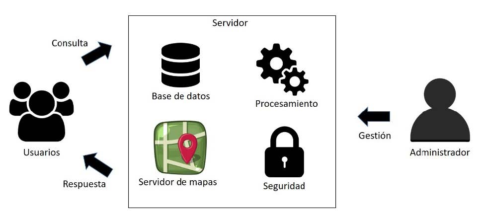
From the concept of Smart City, an Intelligent Campus model is abstracted, supported by geoinformation and information and communication technologies to generate a tool to support mobility within the University Campus. The questions to be solved with the tool are: “where is it”, and “how do I get to”. Using a Campus of 100 hectares and 18 kilometers of paths and tracks arranged in a spatial database, a Geographic Information System is conceived and made available through the Internet as well as a mobile App. A graphical interface of its own so that users can access the application and through “three clicks” they build a question to the system and thus obtain their mobility response. After entering the parameters into the system, the response is built identifying the destination and how to get there, through a shortest route drawn it on the base map of the University, the distance between the origin-destination points and the travel time for a pedestrian. The GisWeb was developed using Geoserver as map server articulated with the Leaflet library for JavaScript, coupled to PostgreSQL database engine with the PostGIS plugin. As a result, a GIS-Web and a mobile application that works both online and offline for Android operating systems were built, by using Apache Cordova framework and Leaflet and framework7 as libraries. UVManos was the name given to the mobile and Web App, and it is a first step in the conception of an Intelligent Campus with which an entire university community is located and moves, facilitating their movement within the University.
Article visits 718 | PDF visits 488
Downloads
Download data is not yet available.
- Balram, S., & Dragicévic, S. (2006). Modeling Collaborative GIS Processes Using Soft Systems Theory, UML and Object Oriented Design. Transactions in GIS, 10(2), 199–218. Retrieved from http://www.omg.org
- Benedito-Bordonau, M., Gallego Tarín, Di., Pere Avariento, J., Sanchis, A., Gould, M., & Huerta, J. (2014). UJI Smart Campus: Un ejemplo de integración de recursos en la Universitat Jaume I de Castelló. IV Jornadas Ibéricas de Infraestructuras de
- Datos Espaciales, 1–12. https://doi.org/10.13140/RG.2.1.3362.6728
- Chen, T. (2021). Smart campus and innovative education based on wireless sensor. Microprocessors and Microsystems, 81. https://doi.org/10.1016/j.micpro.2020.103678
- De, D., Modelo, U. N., De, S., De Metadatos, B., Luna Ramírez’, E., Ambriz, H., … Mondragón, J. N. (2008). DESIGN OF A WEB SEMI-INTELLIGENT METADATA SEARCH MODEL APPLIED IN DATA WAREHOUSING SYSTEMS. In Revista chilena de ingeniería (Vol. 16).
- Douglas Crockford. (2022, March 25). Introducción a JSON.
- Esri Inc. (2022, March 25). Environmental Systems Research Institute.
- Freire, C. E. de A., & Painho, M. (2014). Development of a Mobile Mapping Solution for Spatial Data Collection Using Open-Source Technologies. Procedia Technology, 16, 481–490. https://doi.org/10.1016/j.protcy.2014.10.115
- Fu, T., & Karan, K. (2015). How Big is the World you can Explore? A Study of Chinese College Students’ Search Behavior via Search Engines. Procedia - Social and Behavioral Sciences, 174, 2743–2752. https://doi.org/10.1016/j.sbspro.2015.01.961
- Giffinger, R., Gudrun, H., & Haindlmaier, G. (2010). Smart cities ranking: An effective instrument for the positioning of cities?POSITIONING OF CITIES? Año IV, 7–25. Retrieved from http://www-cpsv.upc.es/ace/Articles_n10/Articles_pdf/ACE_12_SA_10.pdfAccessUPCommons:http://hdl.handle.net/2099/8550
- Greco, I., & Bencardino, M. (2014). LNCS 8580 - The Paradigm of the Modern City: SMART and SENSEable Cities for Smart,Inclusive and Sustainable Growth. In LNCS (Vol. 8580). Retrieved from https://link-springer-com.bd.univalle.edu.co/content/pdf/10.1007%2F978-3-319-09129-7_42.pdf
- Hare, T. M., Rossi, A. P., Frigeri, A., & Marmo, C. (2018). Interoperability in planetary research for geospatial data analysis. Planetary and Space Science, 150, 36–42. https://doi.org/10.1016/j.pss.2017.04.004
- Hobu Inc. (2022, March 25). draft-ietf-geojson-04 .
- Koch, C., Neges, M., König, M., & Abramovici, M. (2014). Natural markers for augmented reality-based indoor navigation and facility maintenance. Automation in Construction, 48, 18–30. https://doi.org/10.1016/j.autcon.2014.08.009
- Kowk, L.-F. (2015). A vision for the development of i-campus _ Enhanced Reader. Smart Learning Environments, 2(2), 1–12. Retrieved from https://slejournal.springeropen.com/articles/10.1186/s40561-015-0009-8
- Moncrieff, S., Turdukulov, U., & Gulland, E. K. (2016). Integrating geo web services for a user driven exploratory analysis. ISPRS Journal of Photogrammetry and Remote Sensing, 114, 294–305. https://doi.org/10.1016/j.isprsjprs.2016.01.015
- Olyazadeh, R., Sudmeier-Rieux, K., Jaboyedoff, M., Derron, M.-H., & Devkota2, S. (2017). An offline–online Web-GIS Android application for fast data acquisition of landslide hazard and risk. Nat. Hazards Earth Syst. Sci., 17, 549–561. Retrieved from https://nhess.copernicus.org/articles/17/549/2017/
- OSGeo Project. (2022, March 25). GeoServer is an open source server for sharing geospatial data.
- Owoc, M., & Mrciniak, K. (2013). Knowledge Management as Foundation of Smart University (Proceedings of the 2013 Federated Conference on Compueter Science and Information Systems, Ed.). Retrieved from https://ieeexplore-ieee-org.bd.univalle.edu.co/stamp/stamp.jsp?tp=&arnumber=6644177
- Pluralsight. (2022, March 25). CELEBRATING 25 years of JavaScript.
- PostGIS. (2022, March 25). Spatial and Geographic objects for PostgreSQL.
- Quser Groups. (2022, March 25). QGIS Un Sistema de Información Geográfica libre y de Código Abierto.
- Schnabel, O., & Hurni, L. (2009). CARTOGRAPHIC WEB APPLICATIONS-DEVELOPMENTS AND TRENDS. Proceedings of the 24th International Cartography Conference. Retrieved from https://icaci.org/files/documents/ICC_proceedings/ICC2009/html/nonref/13_4.pdf
- Shao, D., Tan, X., Liu, H., Yang, H., Xiao, C., & Yang, F. (2013). Performance analysis of on-farm irrigation tanks on agricultural drainage water reuse and treatment. Resources, Conservation and Recycling, 75, 1–13. https://doi.org/10.1016/j.resconrec.2013.03.011
- SQLite Consortium. (2022, March 25). SQLite .
- Steiniger, S., & Bocher, E. (2009). An overview on current free and open source desktop GIS developments. International Journal of Geographical Information Science, 23(10), 1345–1370. https://doi.org/10.1080/13658810802634956
- The Apache Software Foundation. (2022, March 25). Apache Cordova.
- The Open Geospatial Consortium. (2022, March 25). The Home of Location Technology Innovation and Collaboration.
- The PHP Group. (2022, March 25). PHP is a popular general-purpose scripting language that is especially suited to web development.
- The PostgreSQL Global Development Group. (2022, March 25). PostgreSQL: The World’s Most Advanced Open Source Relational Database.
- Torres-Sospedra, J., Avariento, J., Rambla, D., Montoliu, R., Casteleyn, S., Benedito-Bordonau, M., … Huerta, J. (2015). Enhancing integrated indoor/outdoor mobility in a smart campus. International Journal of Geographical Information Science, 29(11), 1955–1968. https://doi.org/10.1080/13658816.2015.1049541
- Trilles, S., Calia, A., Belmonte, Ó., Torres-Sospedra, J., Montoliu, R., & Huerta, J. (2017). Deployment of an open sensorized platform in a smart city context. Future Generation Computer Systems, 76, 221–233. https://doi.org/10.1016/j.future.2016.11.005
- Vladimir Agafonkin. (2022, March 25). Leaflet.
- Vladimir Kharlampidi. (2022, March 25). Build full featured iOS, Android & Desktop apps.
- Wirth, L. (2001). Revista de Estudios Sociales Leer la ciudad. Ensayos de Antropología Urbana El urbanismo como forma de vida * * *.
- Zainuddin, K., Mokhtar, E. S. ., & Yusof, K. W. (2011). Developing a UiTM (Perlis) Web-Based of Building Space Management System_ A Preliminary Study in Locating a Specified Space_Room Area Using Open Source GIS Tool _ Elsevier Enhanced Reader. Procedia Engineering, 20(1), 154–158. https://doi.org/10.1016/J.PROENG.2011.11.150
- Zavala-Romero, O., Ahmed, A., Chassignet, E. P., Zavala-Hidalgo, J., Fernández Eguiarte, A., & Meyer-Baese, A. (2014). An open source Java web application to build self-contained web GIS sites. Environmental Modelling and Software, 62, 210–220. https://doi.org/10.1016/j.envsoft.2014.08.029
- Zhang, L., Liu, Y., Zhan, X., Yang, X., Chi, X., & Zhao, S. (2012). Campus View: An innovative location and context-aware video sharing application on smart phone. Wireless Personal Communications, 66(3), 493–509. https://doi.org/10.1007/s11277-012-0737-9
- Zheng, J., Zhang, Z., Ciepluch, B., Winstanley, A. C., Mooney, P., & Jacob, R. (2013). A PostGIS-based pedestrian way finding module using OpenStreetMap data. International Conference on Geoinformatics. https://doi.org/10.1109/Geoinformatics.2013.6626049